The first we know of Minnehaha Creek is in May 1822, when two 17-year old boys, William J. Snelling, the son of Colonel Snelling, and Joseph Renshaw Brown, a drummer boy from Maryland, followed the creek up to Lake Minnetonka. Snelling couldn’t take the mosquitoes and headed back, but Brown and two soldiers from the fort made it all the way, past Indian settlements, up to Gray’s Bay and Big Island, where they encountered a Chippewa village.
Although their 1823 map inaccurately described the course of the creek, they are thought to be the first white men to leave a record of having passed through the area, which was to become St. Louis Park. For years afterwards, the creek was known as Joe Brown’s River; in 1853, surveyor Jesse T. Jarrett called it Brown’s Creek.
Mills were built on the Creek (also called Little Falls Creek), which was much more powerful than it is today. The mill closest to St. Louis Park was Schussler’s Mill (1874), located off of Excelsior Blvd. at about Powell Road by the Hopkins border. Also nearby was the Waterville Mill (1857), located at 50th and Browndale in Edina. A note in the 1894 Mail newspaper described the water in Minnehaha Creek as “so high that the falls here quite rival that of the Minnehaha.” But a dam was built in 1895 at Grays Bay (Lake Minnetonka), the source of the Creek, lowering the water level and dooming all of the creek’s mills. Foster W. Dunwiddie wrote an article about the Six Flouring Mills on Minnehaha Creek for the Spring 1975 issue of Minnesota History.
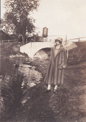
Some of the first settlers built homes along the Creek, and in the Brookside neighborhood, people built summer cottages when the land was first platted in 1907. Creekside property is still sought after today, and many smaller homes that back on to the Creek are often supersizing their homes or tearing them down and starting over with bigger houses. The photo below is of Kay Fox Bevan at the point where Brookside Ave. and Yosemite Ave. meet. It was probably taken in the 1920s.

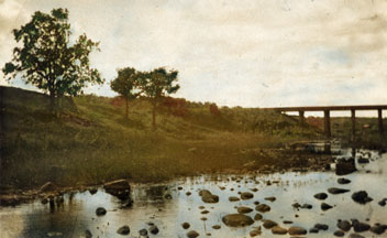
The creek also ran by present-day Knollwood. Here’s a picture taken by the Ruedlingers, probably in the 1920s or 30s.

Back in the early days of the Park, local boys swam (sometimes without benefit of trunks) at “Mosquito Point,” a spot where the Creek ran through the swamp west of the MN&Southern tracks. Between the two bridges the creek made a right angle turn and formed a rather large pond area, with water 5 or 6 ft. deep. Older kids swam at a place known as the Mud Hole, although if the girls were swimming at one place, the boys would go to another.
In July 1917, the Commercial Club looked into dredging the Creek and creating a bathhouse and a beach. A dam was built at Mosquito Point and two bathhouses were erected with lumber and nails provided by Mr. McCarthy and Pockrandt Lumber. The creek has since been straightened out and Mosquito Point is no more.
The June 9, 1945 issue of the St. Louis Park Spectator reported:
To Confer on ‘Haha Creek Conservation
Further plans for the preservation of the shores of Minnehaha Creek in rural Hennepin County will be made at a conference to be held at the office of Chester Wilson, state conservation commissioner, at 1 a.m., Tuesday when a delegation consisting of Mayor O.B. Erickson of St. Louis Park, Mayor T.L. Todd of Edina a members of the Board of County Commissioners will confer with the conservation commissioner on the subject.
In 1949, the County dredged the creek at 4240 Colorado Ave. “for bathing beach and park purposes.” This remains vacant land owned by the City.
On December 7, 1953, Mr. G.A. Morse of the Hopkins Terminal, Inc. explained to the Council how he wanted to change the course of the creek north of Excelsior and east of St. Louis Park. He showed the council the proposed new course, and was told to consult with Village Engineer Phil W. Smith so that he would be informed as to what was being proposed.
In 1954 comes an approval of the State Conservation Commission of proposed changes to the SW ¼ of the NW ¼ of Section 20. The Commission considered the change to be “a desirable improvement for the property in the area adjacent.”
In 1954, the Village asked the County to dredge the creek at 4240 Colorado Ave. as they had done in 1949, but the County refused. The refusal seemed unfair, as the County had just dredged Crystal Lake.
In 1968, L.M. Canfield of the Isaac Walton League appeared before the City Council and complained about dumping in the creek. The Council ordered the Parks and Recreation Commission to study the creek and made recommendations. They also authorized the City to test for pollution.
The creek was dredged in about 1971.
The Mudcat dredged the creek starting October 6, 1981. The Mudcat was designed for dredging lakes and had to be re-anchored several times a week on the creek. The $12,000 cost was picked up by the city (10 percent), the watershed district (30 percent) and property owners along the creek (60 percent).
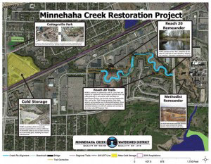
In 2008-09, the Minnehaha Creek Watershed District, in partnership with Methodist Hospital, restored one section o the creek channel and the surrounding wetland area. The channel was relocated to the northeast and created seven deep, flowing curves (meanders) to restore the straightened portion of the creek.
Here’s a site that shows pictures of all the bridges over the creek in St. Louis Park and Edina by John A. Weeks III.

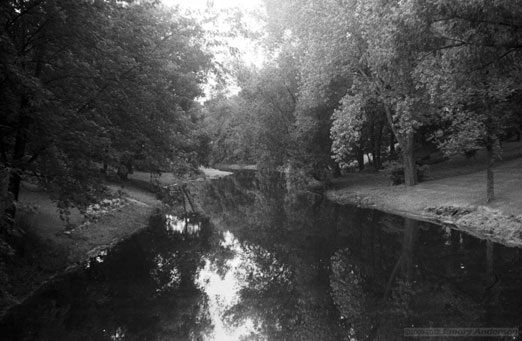
1960 Photo by Emory Anderson
In 2012, plans were made to restore a 3,000-foot stretch of the creek, which had been the site of dumping. The site is between Louisiana Ave. and Meadowbrook Road, upstream from the section that was restored in 2008-09. The project will be funded by $300,000 from a Clean Water Legacy grant from the State, with the remaining $800,000 coming from the Minnehaha Creek Watershed District. See Tom Meersman’s article in the StarTribune. Freezing temperatures in the winter of 2012-13 allowed work to begin, as bulldozers and trucks cleared away trees without sinking into the swamp.

